
The routes of sea transport are distributed among the oceans, which is also the advantage of sea transport over other modes of transport. The routes are restricted by other factors in the system. When choosing a route, the conditions of the cargo, ships, and ports must be taken into consideration. A reasonable choice can only be made after a comprehensive assessment of the system organization. It is a relatively passive factor.
Compared with other modes of transport, the routes of sea transport have the characteristics of low investment and natural formation. At the same time, they are more affected and restricted by natural conditions. This influence and restriction are clearly reflected in the classification of routes. According to different classification standards, sea transport routes can be divided into different types.
1. According to the distance of the voyage
(1)Ocean Going Shipping Line. Refers to international maritime transport between countries or regions through one or more oceans. For example, maritime transport from China to the United States and some European countries is collectively referred to as ocean transport shipping line.
(2)Near-Sea Shipping Line refers to maritime transport routes between ports in a country and ports in neighboring countries. For example, maritime transport shipping lines from China to ports in Japan and South Korea.
(3)Coastal Shipping Line refer to transport shipping lines between ports in a country's coastal areas. For example, the maritime transport line from Shanghai Port to Dalian Port.
(4)Global Shipping Line refer shipping line that connects the Pacific Ocean, Atlantic Ocean, and Indian Ocean for navigation.
2. According to the operation mode of the ship
(1) Regular routes refer to routes that use fixed ships, sail according to fixed sailing schedules and ports, and operate passenger and cargo transportation business at relatively fixed freight rates. Regular routes are also called liner routes, which mainly transport miscellaneous goods.
(2) Irregular routes are routes temporarily selected according to the needs of freight. The ships, sailing schedules, and ports of call are not fixed, and they are routes that mainly operate bulk, low-cost cargo transportation business.
China is a manufacturing powerhouse and a major exporter of container shipping. Every year, a large amount of goods are shipped from various ports in China to all parts of the world. It should be noted that the demand for containers will surge before major holidays such as Golden Week and Spring Festival. This will cause a shortage of containers and a significant increase in transportation costs. If you plan to transport goods during the peak season, you should plan ahead.
There are three main routes for exporting goods from China: the Pacific Ocean, the Atlantic Ocean, and the Indian Ocean.
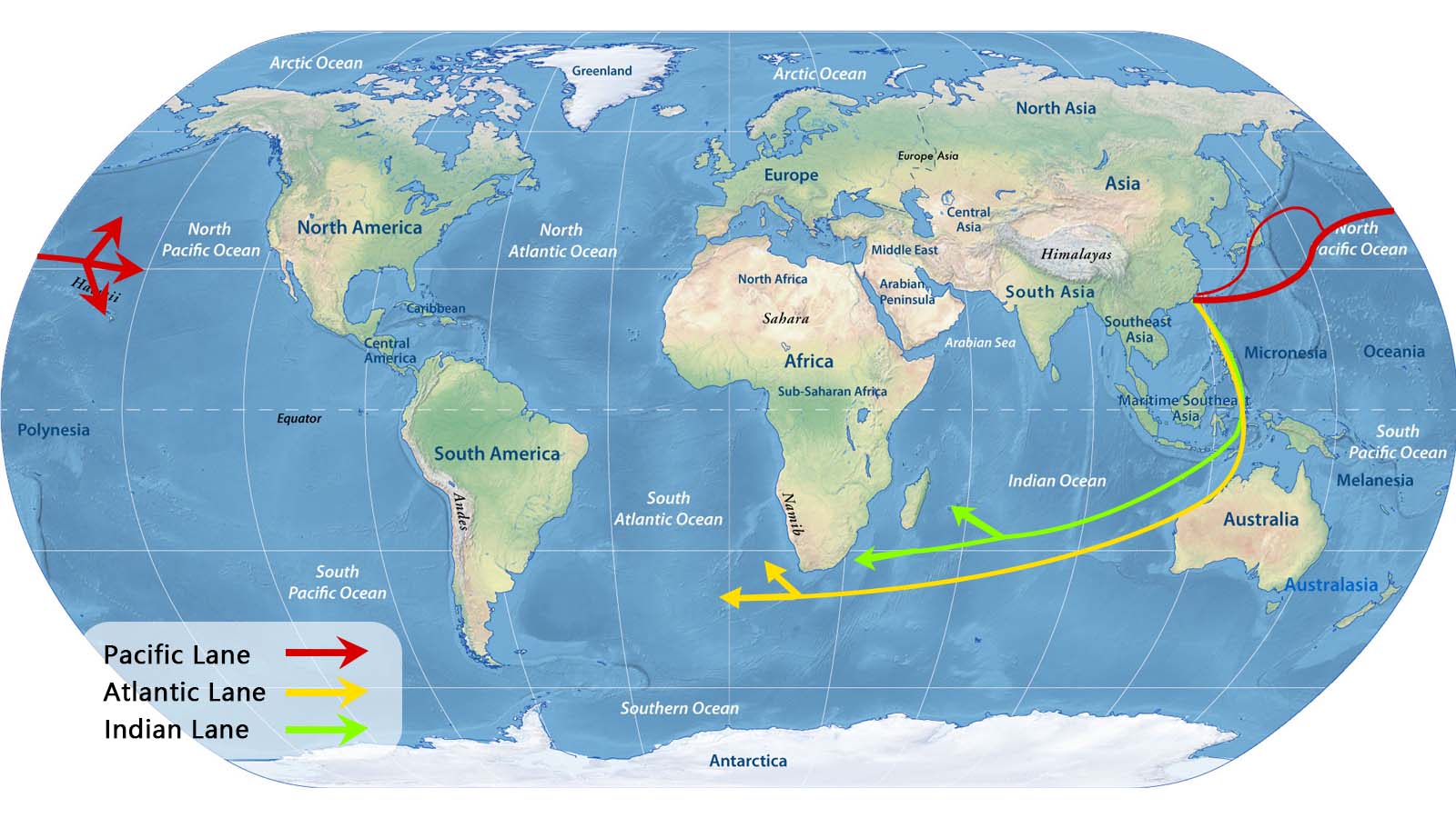
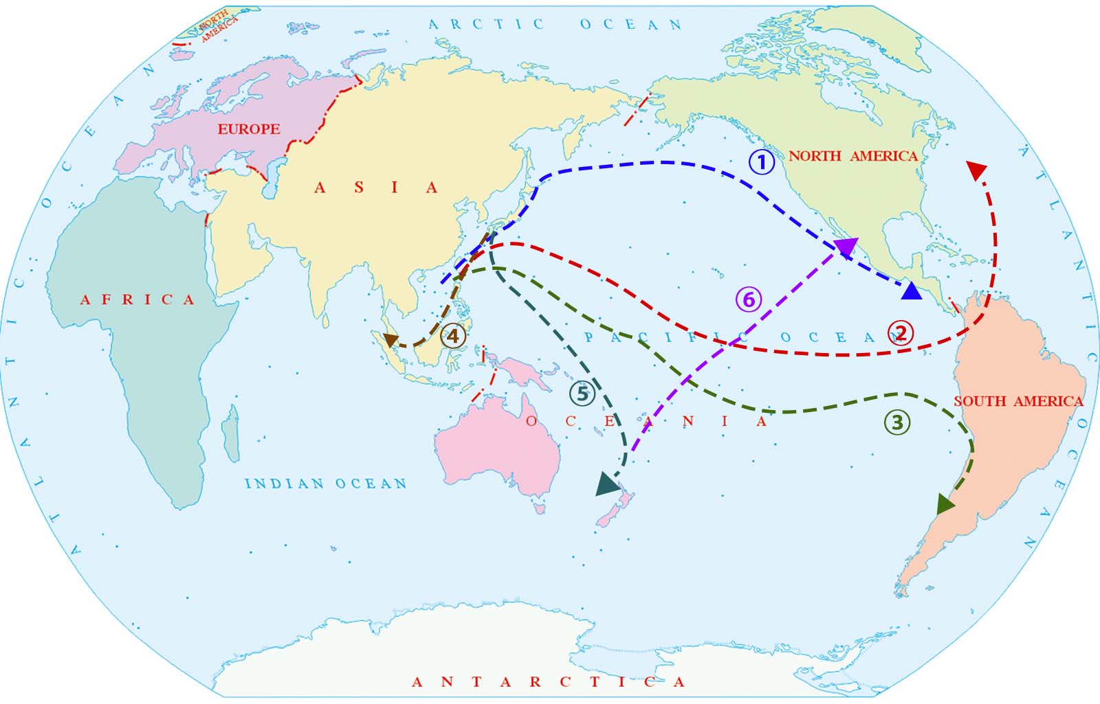
Ⅰ Pacific route: Through the Pacific route, you can transport goods to the west coast and east coast of the United States, the west coast of South America, Southeast Asia, Australia, and New Zealand. The Pacific route includes six common routes.
This route includes trade and transportation lines from the Far East seaports of China, North Korea, South Korea, Japan, and Russia to ports on the west coast of North America, such as Canada, the United States, and Mexico. Usually, the route goes east to high latitudes (with the help of the North Pacific warm current) and the route goes west to low latitudes (with the help of the North Equatorial warm current).
This route also fluctuates with seasonal changes, generally moving north in summer and south in winter to avoid sea fog and storms in the North Pacific.
The ports involved in this route mainly include Shanghai, Shenzhen, Hong Kong, Qingdao, Ningbo-Zhoushan, Tianjin, Guangzhou, Kaohsiung, Busan, Tokyo, Kobe, Yokohama, etc. in the Far East and Vancouver, Seattle, Oakland, San Francisco, Los Angeles and Long Beach, etc. on the west coast of North America.
This route passes through the Hawaiian Islands from north to south and arrives at the Panama Canal. Most ships departing from ports along the northern coast of China will pass through the Osumi Strait or go out of the East China Sea via Amami Oshima in Ryukyu.
Ships departing from ports along the northern coast of China mostly pass through Amami Oshima in Ryukyu. The Iwo Islands, Wake Island, and the Line Islands south of the Hawaiian Islands cross the equator into the South Pacific and go to ports on the west coast of South America
This route is the main route for cargo ships from China, South Korea (North Korea), and Japan to ports in Southeast Asia, and to ports on the Indian Atlantic coast via the Strait of Malacca. The East China Sea, Taiwan Strait, Bashi Strait, and South China Sea are the only routes for ships on this route, and the route is busy.
There are two routes from the Far East to the southeast coast of Australia.
From Australia and New Zealand to the North American coast, most of the routes go through Suva, Honolulu, and other important Pacific ports. To the east coast of North America, the route is through Papeete in the Society Islands and through the Panama Canal.
Pacific Route
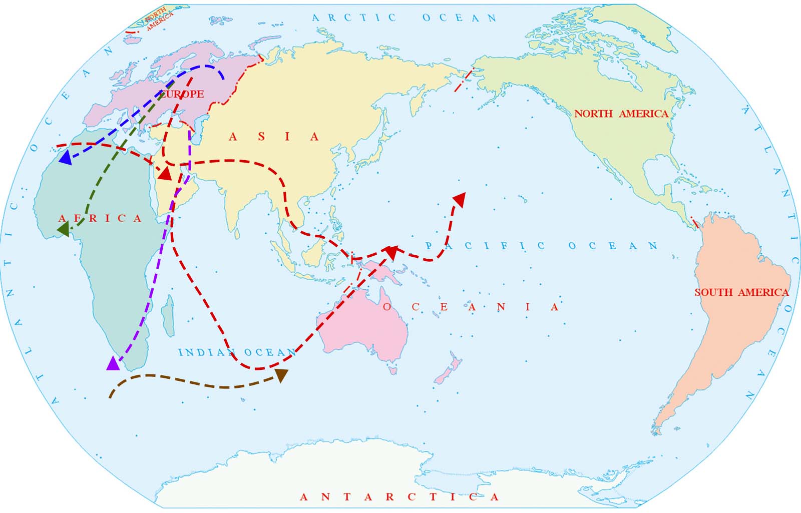
Ⅱ Atlantic route: Ships can also choose the Atlantic route. Sailing south from China, passing through the Indian Ocean and bypassing the Cape of Good Hope. This route can lead to Western Europe, the east coast of the United States, the Suez Canal, the Persian Gulf, the Mediterranean region and the Red Sea.
This route is a transportation line for the exchange of raw materials, fuels and products between Western Europe and North America, the two most industrially developed regions in the world. Both sides have important ports in the world, and transportation is extremely busy. Most ships take the North Atlantic route. The area has strong winds and waves in winter, and there are thick fog and icebergs, which threaten navigation safety.
This route mostly crosses the North Atlantic after leaving the English Channel. Like ships departing from ports on the east coast of North America, they generally enter the Caribbean Sea through Mona and the Windward Strait. In addition to the ports along the Caribbean coast, you can also reach the Pacific coast ports of America through the Panama Canal.
This route is the world's busiest route. It is a shortcut for trade between North America, Northwest Europe and the Asia-Pacific Gulf region. This route generally passes through the terminals on the Azores and Madeira Islands.
This route generally passes through the terminals on the Atlantic Islands of West Africa--Canary Islands and Cape Verde Islands.
This route is generally an oil route for giant tankers. Cape Verde Islands and Canary Islands are the main terminals for passing ships.
This is a transportation line mainly for oil and ore. This route is located in the westerly drift sea area with strong winds and waves. Generally, westbound flights tend to go north, and eastbound flights tend to go south.
Atlantic Route
Ⅲ Indian Ocean route: Another route is to transport Chinese products to the Persian Gulf, East Africa, and Western Europe via the Indian Ocean. The Indian Ocean route is mainly an oil transportation line, and there are also many transit transportation of bulk goods.
This route is mainly operated by supertankers and is the world's most important maritime oil transportation line.
This route is currently accessible to supertankers with a load capacity of up to 220,000 tons.
This route goes east through the Strait of Malacca (ships with a deadweight of less than 200,000 tons are feasible) or Lombok and Makassar Straits (supertankers with a deadweight of more than 200,000 tons are feasible) to Japan.
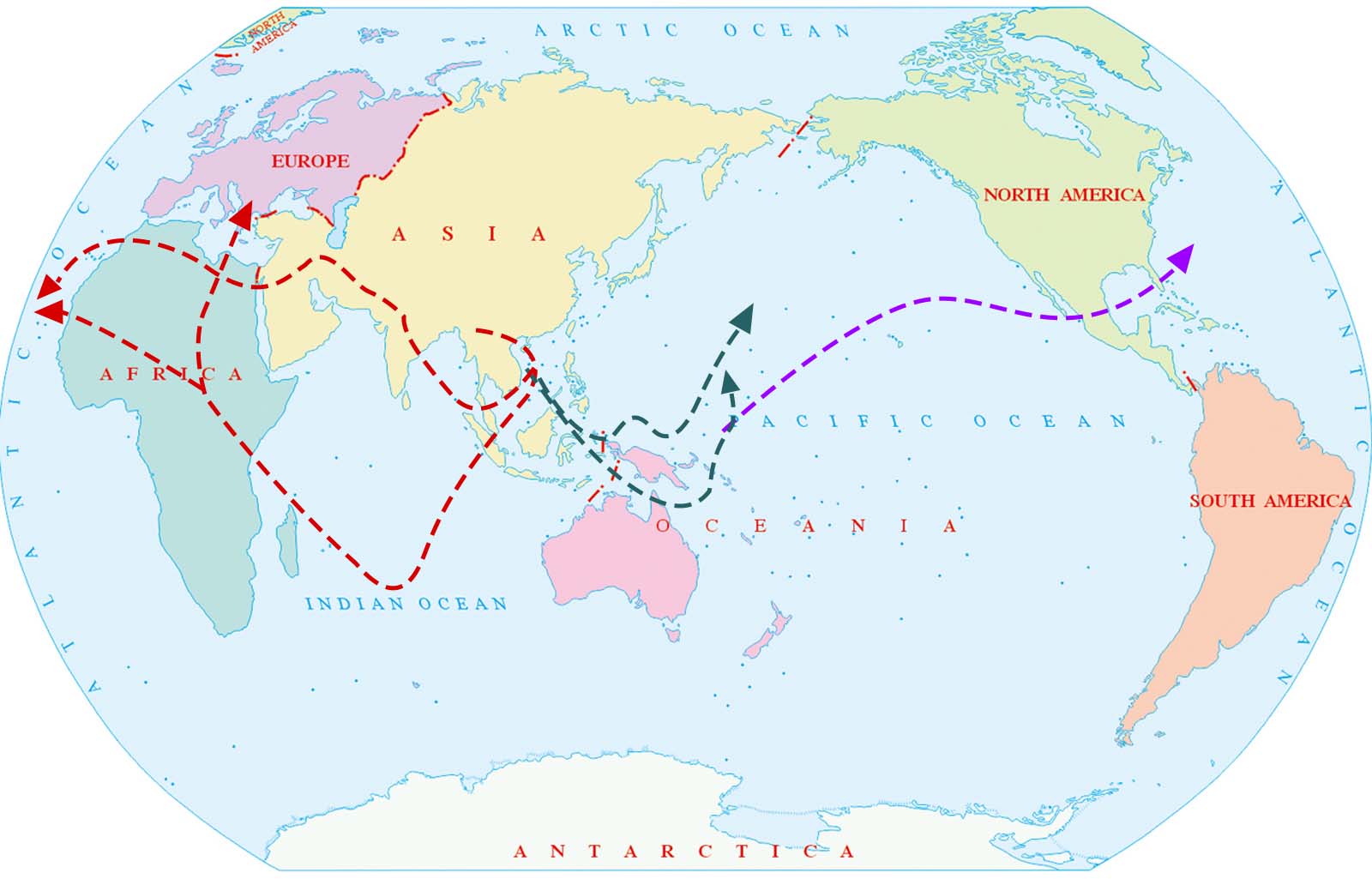
Indian Ocean Route
For many years, China has been the world's largest exporter of goods. In November 2023, my country's exports reached US$292 billion, with major exports including mobile phones, computers, integrated circuits, and automobiles. Among China's major trading partners, the United States occupies a considerable share.
In recent years, with the overall tight balance of the global container shipping market, there has been a significant linkage effect between various routes. Large fluctuations in other routes sometimes have an impact on European freight rates. The US route is currently the route with the highest container transportation volume.
The top five ports in terms of container throughput in the United States are Los Angeles, Long Beach, New York New Jersey, Savannah, and Houston. The ports with the largest container throughput in China are Shanghai, Shenzhen, and Ningbo-Zhoushan. The Shanghai-US container routes can be divided into West Coast, US East Coast, and US Gulf based on the destination. Among them, the US West Coast and US East Coast routes are the most common routes with the largest trade volume.
The US West Coast route refers to ships departing from ports such as Shanghai and heading directly east across the Pacific Ocean to reach US West Coast ports such as Los Angeles and Long Beach. The voyage is close to 6,000 nautical miles. Most ships usually take 15-20 days, and some fast ships can reach their destination in 11 days.
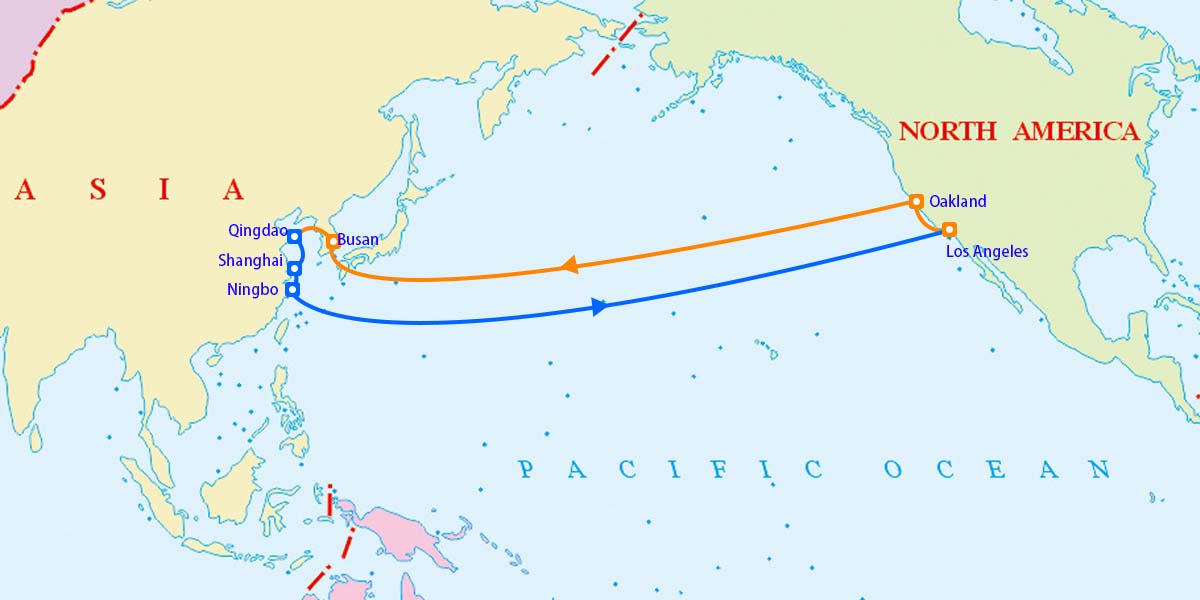
US West Coast Route
In the past, the US route was mainly to the West Coast. After the epidemic, the congestion of West Coast ports and the unresolved labor negotiations at West Coast terminals have led to the transfer of some cargo to the East Coast. The cargo volume at the East US ports increased significantly.
There are two container shipping routes from China to the East Coast of the United States, one through the Panama Canal and the other through the Suez Canal. The round-trip voyage takes 70-80 days.
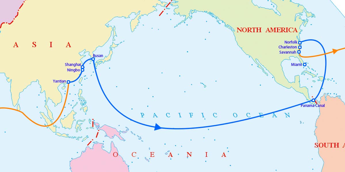
US East Coast Route (AWE7)
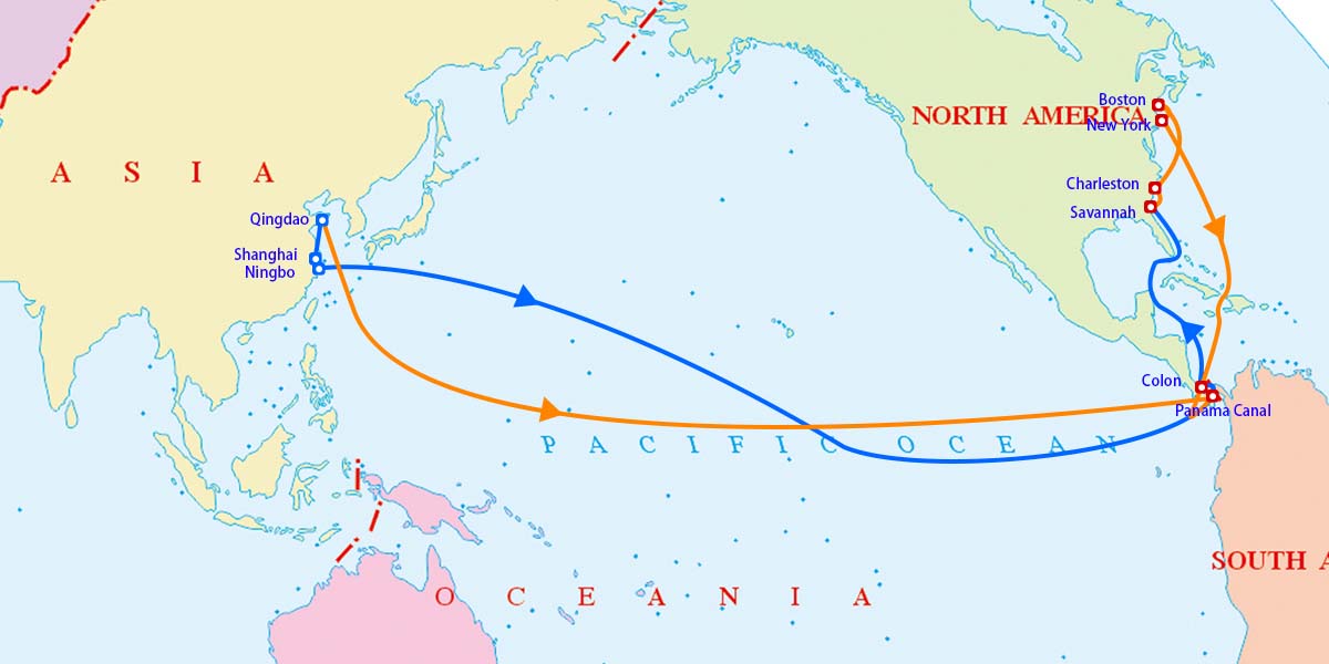
US East Coast Route (AWE1)
Similar to the China-US East Coast route, the China-US Gulf route can also be divided into the eastbound route across the Pacific Ocean via the Panama Canal to reach the US Gulf, and the westbound route via the Suez Canal across the Atlantic Ocean to reach the US Gulf.
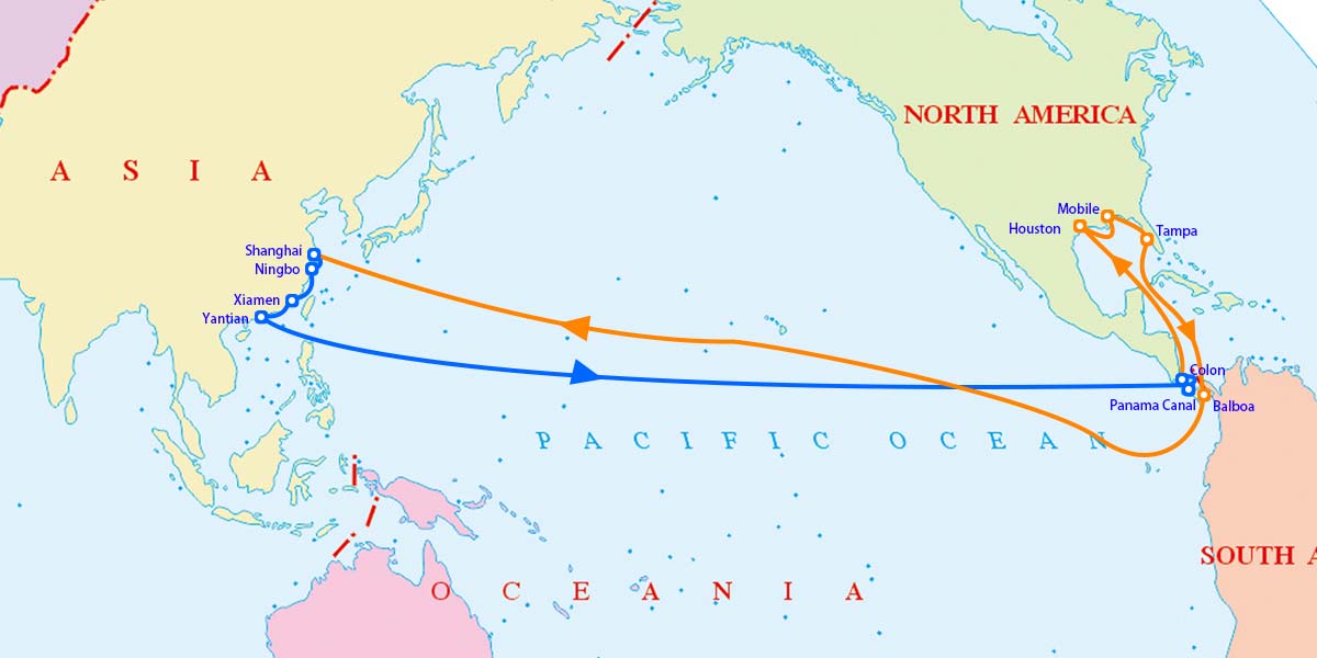
US Gulf Route
Ocean shipping is the main mode of transportation in international trade. Many importers and exporters will encounter certain difficulties in transportation costs when transporting goods. The factors affecting ocean shipping costs are as follows:
1.Port routes.
Different routes have different navigation conditions, and the impact on ship transportation costs is also different. Route distance, weather conditions, safety, etc. will also be reflected in the freight rate. Port conditions that affect freight rates include port loading and unloading rates, port charges, port loading and unloading equipment berth conditions, loading and unloading efficiency, management level, congestion and safety.
2.Market conditions.
The shipping market structure is one of the main factors affecting freight prices. The sea transportation of goods is divided into off-season and peak season. If the shipping company accepts more goods in the peak season, the quotation will naturally rise.
3.The characteristics of the goods.
Goods have the greatest impact on international ocean shipping costs. In the process of cargo transportation, they are mainly affected by the value, nature and weight of the goods. Generally speaking, if the goods are more expensive or dangerous goods, the freight will be higher. In addition, if the goods are heavier, affecting the space and tonnage of the ship, the freight will also be relatively high.
4. Terms of the transport contract.
The transport conditions stipulated in the transport contract, such as the freight payment method, cost responsibility, and the carrier's liability range, will affect the freight rate.
5. Freight forwarding companies.
Freight forwarding companies will also affect international ocean freight rates.
6. Exchange rate.
Most of the shipping costs are settled in US dollars, so they will be affected by the exchange rate fluctuations at the time.
Shipping routes are the lifeline of international trade, connecting major economic regions and ports. Being familiar with shipping routes helps importers estimate transportation costs, have a certain psychological expectation of shipping risks, and facilitate customers to deal with unexpected transportation crises. China-US trade is an important sector in the international trade landscape. Knowing China-US shipping routes in advance will have a far-reaching impact on China-US trade, as well as trade between China and other countries.
Affected by various international and domestic factors, the world's shipping routes will also face certain challenges and opportunities. CSMC will continue to pay attention to the development of news that affects the steel industry and actively provide customers with useful information.
We sincerely hope that the information we provide can make more beneficial value. In addition, we sincerely invite you to leave valuable comments and advice on our website. We will follow your comments and advice at any time on our website.
CSMC-Empowering small and medium-scale steel purchasing.
Editor: Gianna Hana
Mail: cs@chinasteelmarket.com



|

|

|

|

|
| Timely Info | Independent | Platform | Multiple guarantees | Self-operated storage |
| About us | Channel | Useful tools |
|---|---|---|
| About China Steel Market | Prices | Steel Weight Calculation |
| Contact Us | Answers | Why Choose Us |
| Terms & Conditions | Inventory | |
| Privacy Policy | Help |
Hot search words: